LongleyRice
Longley-Rice propagation model
Description
Model the behavior of electromagnetic radiation from a point of transmission over
irregular terrain, including buildings, by using the Longley-Rice model, also known at the
Irregular Terrain Model (ITM). For more information about the model, see [1]. Represent the model by using a
LongleyRice object.
The Longley-Rice model:
Is designed for frequencies from 20 MHz to 20 GHz, distances from 1 to 2000 km, and antenna heights from 0.5 to 3000 m.
Calculates path loss from free-space loss, terrain and obstacle diffraction, ground reflection, atmospheric refraction, and tropospheric scatter.
Provides path loss estimates by combining physics with empirical data statistics.
To predict path loss in scenes that feature buildings, such as urban environments,
consider using a ray tracing propagation model. For more information about ray tracing models,
see RayTracing.
Note
The LongleyRice object implements the point-to-point mode of the
model, which uses terrain data to predict the loss between two points.
Creation
Create a LongleyRice object by using the propagationModel
function.
Properties
Examples
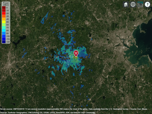
Display the coverage area for a transmitter using the Longley-Rice model.
pm = propagationModel("longley-rice");
tx = txsite("Name","Apple Hill","Latitude",42.3001,"Longitude",-71.3604);
coverage(tx,pm,"SignalStrengths",-100:-5)
Increase the time and situation variability tolerance levels from 0.5 (the default) to 0.9. Display the coverage area for the transmitter using the updated propagation model.
pm.TimeVariabilityTolerance = 0.9;
pm.SituationVariabilityTolerance = 0.9;
coverage(tx,pm,"SignalStrengths",-100:5)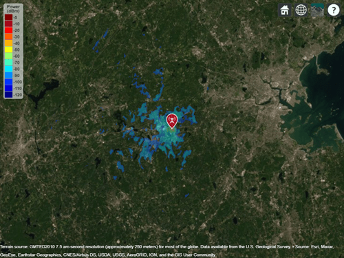
The coverage area is smaller for the model with higher variability tolerance levels.
More About
Tips
By default, functions that accept a LongleyRice object as input use
terrain elevation data hosted by MathWorks® and derived from the GMTED2010
model by the USGS and NGA. To use terrain elevation data from DTED files instead, first add
the terrain by using the addCustomTerrain function.
Then, use the terrain by specifying the Terrain property of a siteviewer object or by
specifying the Map argument of a propagation function such as sigstrength or sinr.
References
[1] Hufford, George A., Anita G. Longley, and William A.Kissick. A Guide to the Use of the ITS Irregular Terrain Model in the Area Prediction Mode. NTIA Report 82-100. National Telecommunications and Information Administration, April 1, 1982.
[2] Seybold, John S. Introduction to RF Propagation. Hoboken, N.J: Wiley, 2005.
Version History
Introduced in R2019b