Main Content

radarScanController

R2026b

Scan controller for radars

Since R2026b

    Description

    radarScanController creates scan controller objects that define mechanical and electronic sector and raster patterns for radars, returned as one of:

    • MechanicalRasterScanner – Defines the scan pattern for a mechanically steered antenna array over a 2-D angular raster.

    • MechanicalSectorScanner – Defines the scan pattern for a mechanically steered antenna array over a 1-D angular sector span.

    • ElectronicRasterScanner – Defines the scan pattern for an electronically steered antenna array over a 2-D angular raster.

    • ElectronicSectorScanner – Defines the scan pattern for an electronically steered antenna array over a 1-D angular sector span.

    Mechanical scanners sweep through scan angles continuously at a fixed rate and then return to the initial position. Electronic scanners dwell at discrete scan angles, and the return to the initial position is instantaneous.

    You can use scan controllers to implement surveillance scanning for radars that lack built-in scanning capabilities, including bistaticTransmitter and bistaticReceiver objects, as shown in Radar Surveillance Scan Pattern Tutorial.

    Creation

    Description

    scanner = radarScanController(scanmode,scantype) creates a scan controller object scanner with a "Mechanical" or "Electronic" scan mode and a "Sector" or "Raster" scan type.

    example

    scanner = radarScanController(scanmode,scantype,PropertyName=Value) creates a scan controller object, with each specified PropertyName set to the corresponding Value. You can specify additional pairs of arguments in any order as PropertyName1=Value1,...,PropertyNameN=ValueN.

    example

    Properties

    expand all

    Scan mode, specified as one of:

    • "Mechanical" – Implements a mechanically steered scan pattern.

    • "Electronic" – Implements an electronically steered scan pattern.

    Data Types: string | char

    Scan type, specified as one of:

    • "Raster" – Implements a 2-D angular raster scan pattern.

    • "Sector" – Implements a 1-D angular sector span pattern.

    Data Types: string | char

    Any scanmode

    Scan time duration, specified as a positive scalar. Units are in seconds.

    scanmodescantypeDescriptionDefault
    "Mechanical""Raster"

    The scan duration is the amount of time it takes to mechanically scan the antenna between the scan limits for the raster search pattern defined by the AzimuthLimits, ElevationLimits, NumBars, and Alignment properties.

    1
    "Mechanical""Sector"

    The scan duration is the amount of time it takes to mechanically scan the antenna between the sector scan limits defined by the AzimuthLimits property.

    5
    "Electronic""Raster"

    The scan duration is the amount of time it takes to electronically scan the antenna between the raster search pattern defined by the AzimuthLimits, ElevationLimits, NumBars, and Alignment properties.

    1
    "Electronic""Sector"

    The scan duration is the amount of time it takes to electronically scan the antenna between the sector scan limits defined by the AzimuthLimits property.

    1

    Dependencies

    To enable this property for "Mechanical" scanmode, set the ScanRateSource property to "Auto".

    To enable this property for "Electronic" scanmode, set the DwellTimeSource property to "Auto".

    This property is not applicable when both AzimuthLimits and ElevationLimits span zero degrees, indicating a stationary scanner.

    Data Types: double

    Start and stop scan limits in the azimuth dimension of the angular sector scanned or searched by the sector or raster pattern, specified as a 2-element vector, where the first element is the initial limit and the second element is the final limit. The total angular sector span defined by AzimuthLimits cannot exceed 360°. In other words, abs(stopstart) ≤ 360. Units are in degrees.

    scanmodescantypeDescriptionDefault
    "Mechanical""Raster"

    Start and stop scan limits in the azimuth dimension of the angular sector searched by the raster pattern, specified as a 2-element vector, where the first element is the initial limit and the second element is the final limit.

    [-90 90]
    "Mechanical""Sector"

    Start and stop scan limits in the azimuth dimension of the angular sector scanned by the sector, specified as a 2-element vector, where the first element is the initial limit and the second element is the final limit.

    [0 360]
    "Electronic""Raster"

    Start and stop scan limits in the azimuth dimension of the angular sector searched by the raster pattern, specified as a 2-element vector, where the first element is the initial limit and the second element is the final limit.

    [-90 90]
    "Electronic""Sector"

    Start and stop scan limits in the azimuth dimension of the angular sector scanned by the sector, specified as a 2-element vector, where the first element is the initial limit and the second element is the final limit.

    [-90 90]

    Note

    Sector scanning objects ("Sector" scantype) only scan in the azimuth dimension whereas raster search objects ("Raster" scantype) scan in two dimensions, with the elevation limits specified by the ElevationLimits property.

    Data Types: double

    "Mechanical" scanmode

    Source of mechanical scan rate, specified as "Auto" or "Property". The default value is "Auto".

    • "Auto" – The scan rate is automatically calculated.

      • scantypeDescription
        "Raster"

        The scan rate is computed as the absolute value of the total angular raster span divided by the scan duration, where the total angular raster span is determined from the AzimuthLimits, ElevationLimits, NumBars, and Alignment properties and the scan duration is defined by the ScanDuration property.

        "Sector"

        The scan rate is computed as the absolute value of the total angular sector span divided by the scan duration, where the total angular sector span is determined from the AzimuthLimits property and the scan duration is defined by the ScanDuration property.

    • "Property" – The scan rate is defined by the ScanRate property.

    Dependencies

    This property is not applicable when both AzimuthLimits and ElevationLimits span zero degrees, indicating a stationary scanner.

    Data Types: string | char

    Mechanical scan rate, specified as 2-element row vector for raster scans or a positive scalar for sector scans. Units are in degrees per second (deg/s).

    scantypeDescriptionDefault
    "Raster"

    The scan rate is specified as a 2-element vector, where the first element is the scan rate along the azimuth axis and the second element is the scan rate along the elevation axis. The antenna mechanically scans between the azimuth and elevation scan limits defined by the AzimuthLimits and ElevationLimits properties.

    [1 1]
    "Sector"

    The scan rate is specified as a positive scalar. The antenna mechanically scans from the initial start angle to the final stop angle defined by the AzimuthLimits property.

    1

    Dependencies

    To enable this property, set the ScanRateSource property to "Property".

    This property is not applicable when both AzimuthLimits and ElevationLimits span zero degrees, indicating a stationary scanner.

    Data Types: double

    Mechanical scan pattern reset behavior, specified as "Return" or "Reverse". This property is not applicable for a scan pattern that ends at its starting position, such as a 360° sweep. The default value is "Return" when

    • "Return" – The scan pattern resets after completing a full scan by returning to its initial position before executing the next scan. The time required for the mechanical slew to return to the initial position is defined by the ReturnDuration property.

    • "Reverse" – The scan pattern resets after the completion of a full scan pattern by reversing the direction of the scan pattern, retracing the scan pattern in the opposite sequence as the previous scan to arrive back at the initial position.

    Dependencies

    This property is not applicable when both AzimuthLimits and ElevationLimits span zero degrees, indicating a stationary scanner.

    Data Types: string | char

    Mechanical scan return time duration or flyback time, specified as a nonnegative scalar. The default value is 0. Units are in seconds.

    scantypeDescriptionDefault
    "Raster"

    The return duration is the amount of time it takes to mechanically slew the antenna back to the initial start position defined by the AzimuthLimits and ElevationLimits properties.

    0
    "Sector"

    The return duration is the amount of time it takes to mechanically slew the antenna back to the initial start position defined by the AzimuthLimits property.

    — (This property is not applicable for the [0 360] AzimuthLimits default setting.)

    Dependencies

    To enable this property, set the ScanReset property to the default value of "Return".

    This property is not applicable when both AzimuthLimits and ElevationLimits span zero degrees, indicating a stationary scanner.

    This property is not applicable for a scan pattern that ends at its starting position, such as a 360° sweep.

    Data Types: double

    "Electronic" scanmode

    Source of electronic dwell time, specified as "Auto" or "Property". The default value is "Auto".

    • "Auto" – The dwell time is automatically calculated:

      • scantypeDescription
        "Raster"

        The dwell time is computed as the ratio of the step angle and scan rate, where the step angle is defined by the StepAngle property and the scan rate is the absolute value of the total angular raster span divided by the scan duration. The total angular raster search span is determined from the AzimuthLimits, ElevationLimits, and NumBars properties and the scan duration is defined by the ScanDuration property.

        "Sector"

        The dwell time is computed as the ratio of the step angle and scan rate, where the step angle is defined by the StepAngle property and the scan rate is the absolute value of the total angular span divided by the scan duration. The total angular sector span is determined from the AzimuthLimits property and the scan duration is defined by the ScanDuration property.

    • "Property" – The dwell time is defined by the DwellTime property.

    Dependencies

    This property is not applicable when both AzimuthLimits and ElevationLimits span zero degrees, indicating a stationary scanner.

    Data Types: string | char

    Duration of time spent at each electronic scan angle, specified as a positive scalar. The default value is 0.1. Units are in seconds.

    Dependencies

    To enable this property, set the DwellTimeSource property to "Property".

    This property is not applicable when both AzimuthLimits and ElevationLimits span zero degrees, indicating a stationary scanner.

    Data Types: double

    Electronic step angle or how much the electronic scan angle changes between dwell times, specified as a nonnegative scalar. For the duration of a dwell, the electronic scan angle remains constant and only changes between dwells. When the step angle is larger than the total angular span, the scanner remains at the initial start angle. The default value is 1. Units are in degrees (deg).

    scantypeDescription
    "Raster"

    The electronic step angle defines how much the electronic scan angle changes along the primary scan direction between dwell times. The primary scan direction is defined by the Alignment property. If the StepAngle is set to 0, the scan will still step along the secondary axis with spacing determined by the NumBars property.

    "Sector"

    The electronic step angle defines how much the electronic scan angle changes between dwell times and must be less than the angle spanned by AzimuthLimits.

    Dependencies

    This property is not applicable when both AzimuthLimits and ElevationLimits span zero degrees, indicating a stationary scanner.

    Data Types: double

    "Raster" scantype

    Start and stop scan limits in the elevation dimension of the angular sector scanned by the 2-D raster pattern, specified as a 2-element vector, where first element is the initial limit and the second element is the final limit. The total angular sector span defined by ElevationLimits cannot exceed 180°. In other words, abs(stopstart) ≤ 180. Units are in degrees (deg).

    Data Types: double

    Alignment or primary direction of the raster scan pattern, specified as "Azimuth" or "Elevation". The raster scan consists of a primary scan direction and a secondary or scan direction. The sensor repeatedly scans along the primary direction while incrementally stepping along the secondary direction to cover the scan area.

    • When this property is set to "Azimuth", the primary scan is performed over the angular span defined by the AzimuthLimits property. Upon reaching the end of the azimuth span, the scanner advances along the secondary elevation direction to the next raster bar and then performs another primary scan across the azimuth span.

    • When this property is set to "Elevation", the primary scan is performed over the angular span set by the ElevationLimits property. Upon reaching the end of the elevation span, the scanner advances along the secondary azimuth direction to the next raster bar and then performs another primary scan across the elevation span.

    Dependencies

    This property is not applicable when both AzimuthLimits and ElevationLimits span zero degrees, indicating a stationary scanner.

    Data Types: string | char

    Number of raster bars in the search pattern, specified as a positive integer scalar. The number of raster bars specifies the number of scans in the primary direction that must be completed before repeating the raster search pattern. A bar is one continuous scan or sweep in the primary direction (defined by the Alignment property) at a fixed angle in the secondary direction. After one bar is completed, the antenna steps in the secondary direction. The number of steps along the secondary scan direction is NumBars–1. The default value is 2.

    Note

    Set this property to a value of 1 to force a 1-D scan.

    Dependencies

    This property is not applicable when both AzimuthLimits and ElevationLimits span zero degrees, indicating a stationary scanner.

    Data Types: double

    Read Only

    This property is read-only.

    Current scan time, returned as a nonnegative scalar. Units are in seconds.

    Data Types: double

    This property is read-only.

    Current scan angle in units of degrees (deg), returned as a scalar or 2-element row vector.

    • "Raster" – 2-element row vector, where the first element is the azimuth angle and the second element is the elevation angle.

    • "Sector" – Scalar azimuth angle.

    Data Types: double

    Object Functions

    scanAdvances the scan position to the desired time
    isScanDoneDetermine if the current scan frame is complete
    isLockedDetermine if the radar scan controller object is locked
    releaseRelease radar scan controller object
    coverageConfigCoverage configuration for radar scan controller object

    Examples

    collapse all

    Create an electronic sector scan controller that scans the azimuth sector from -30 to 30 degrees for a bistatic transmitter that has a fan beam with a 10-degree azimuth beamwidth and a 30-degree elevation beamwidth.

    Define the bistatic transmitter.

    freq = 300e6;
    txAnt = phased.SincAntennaElement(Beamwidth=[10 30]);
    txRdr = bistaticTransmitter(TransmitAntenna=phased.Radiator(Sensor=txAnt,OperatingFrequency=freq));

    Create a radar scenario and position a moving platform for the bistatic transmitter.

    scnro = radarScenario;
    traj = kinematicTrajectory(Position=[0 10e3 0],Orientation=quaternion([-90 0 0],"eulerd","ZYX","frame"));
    txPlat = platform(scnro,Trajectory=traj);

    Set the scan duration to 31 pulse repetition intervals (PRIs) so the beam sweeps slowly enough to capture the full transmit antenna pattern as it traverses the receive antenna's location.

    pri = 1/txRdr.Waveform.PRF;
    txScnr = radarScanController("Electronic","Sector",AzimuthLimits=[-30 30],ScanDuration=31*pri)
    txScnr = 
      ElectronicSectorScanner with properties:
    
          AzimuthLimits: [-30 30]
           ScanDuration: 0.0031
              StepAngle: 1
        DwellTimeSource: "Auto"
              ScanAngle: -30
               ScanTime: 0


    Create a default coverage configuration structure using coverageConfig.

    txCovCfg = coverageConfig(txScnr)
    txCovCfg = struct with fields:
              Index: 1
          LookAngle: [-30 0]
        FieldOfView: [0 0]
         ScanLimits: [-30 30]
              Range: 1
           Position: [0 0 0]
        Orientation: [1×1 quaternion]


    Update the default coverage configuration to include information about the bistatic transmitter and platform.

    txCovCfg.Index = txPlat.PlatformID;
    txCovCfg.Range = 20e3;
    txCovCfg.FieldOfView = txRdr.TransmitAntenna.Sensor.Beamwidth;
    txCovCfg.Position = txPlat.Position;
    txCovCfg.Orientation = quaternion(txPlat.Orientation,"eulerd","ZYX","frame")
    txCovCfg = struct with fields:
              Index: 1
          LookAngle: [-30 0]
        FieldOfView: [10 30]
         ScanLimits: [-30 30]
              Range: 20000
           Position: [0 10000 0]
        Orientation: [1×1 quaternion]


    Plot the scan coverage using theaterPlot, coveragePlotter, and plotCoverage.

    fig = figure(Name="Scan Coverage");
    clf(fig);
    ax = axes(fig);
    tp = theaterPlot(Parent=ax,AxesUnits=["km" "km" "km"], ...
        XLimits=25e3*[-1 1],YLimits=25e3*[-1 1],ZLimits=25e3*[-1 1]);
    title(ax,"Tx Scan Coverage");
    view(ax,20,20);
    
    txCovPltr = coveragePlotter(tp,DisplayName="Tx Coverage");
    plotCoverage(txCovPltr,txCovCfg);
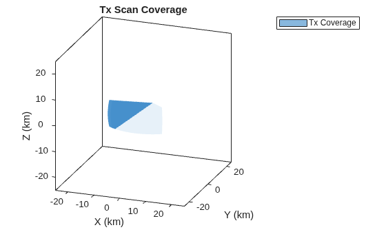
    Figure Scan Coverage contains an axes object. The axes object with title Tx Scan Coverage, xlabel X (km), ylabel Y (km) contains an object of type patch. This object represents Tx Coverage.

    Create a mechanical raster scan controller that scans from -30 to 30 degrees in azimuth and -5 to 25 degrees in elevation for use with a pencil beam bistatic transmitter.

    txScnr = radarScanController("Mechanical","Raster",AzimuthLimits=[-30 30],ElevationLimits=[-5 25])
    txScnr = 
      MechanicalRasterScanner with properties:
    
          AzimuthLimits: [-30 30]
        ElevationLimits: [-5 25]
           ScanDuration: 1
                NumBars: 2
              Alignment: "Azimuth"
              ScanReset: "Return"
         ReturnDuration: 0
         ScanRateSource: "Auto"
              ScanAngle: [-30 -5]
               ScanTime: 0


    Define the bistatic transmitter to have a 10 degree field of view.

    freq = 300e6;
    fov = [10 10]; % [az el] degrees
    txAnt = phased.SincAntennaElement(Beamwidth=fov);
    txRdr = bistaticTransmitter(TransmitAntenna=phased.Radiator(Sensor=txAnt,OperatingFrequency=freq));

    The raster scanner sweeps along its primary scan direction, defined by the Alignment property. When it reaches the end of the primary axis (azimuth in this case), it steps along the secondary axis to the next raster bar. Raster bars are spaced evenly between the secondary limits, and the scanner reverses its primary scan direction each time it steps to a new bar.

    For a pencil beam with a 10-degree beamwidth in both azimuth and elevation, the 30-degree elevation span requires 30/10 + 1 = 4 raster bars to cover the full surveillance volume.

    txScnr.NumBars = floor(diff(txScnr.ElevationLimits)/fov(2)) + 1
    txScnr = 
      MechanicalRasterScanner with properties:
    
          AzimuthLimits: [-30 30]
        ElevationLimits: [-5 25]
           ScanDuration: 1
                NumBars: 4
              Alignment: "Azimuth"
              ScanReset: "Return"
         ReturnDuration: 0
         ScanRateSource: "Auto"
              ScanAngle: [-30 -5]
               ScanTime: 0


    Create a stationary scanner that does not scan its antenna by setting both azimuth limits to the same value. This forces the scanner to stare at a fixed angle. Set that angle to 0 degrees.

    rxScnr = radarScanController("Mechanical","Sector",AzimuthLimits=[0 0])
    rxScnr = 
      MechanicalSectorScanner with properties:
    
        AzimuthLimits: [0 0]
            ScanAngle: 0
             ScanTime: 0


    Version History

    Introduced in R2026b