getMapROI
Description
Add-On Required: This feature requires the Scenario Builder for Automated Driving Toolbox add-on.
mapParameters = getMapROI(lat,lon)mapParameters.
mapParameters = getMapROI(lat,lon,Extent=extent)
Examples
Extract map ROI parameters from GPS data. Use the extracted osmUrl parameter to import roads from the OpenStreetMap® web service into a driving scenario. Then, plot the scenario.
Load GPS data containing latitude and longitude values into the workspace.
load("GPSData.mat")Use the latitude and longitude to fetch the map parameters.
mapParameters = getMapROI(gps.lat,gps.lon);
Use the osmUrl parameter in the mapParameters output structure to import and save the OpenStreetMap file.
fileName = websave("drive_map.osm",mapParameters.osmUrl, ...
    weboptions(ContentType="xml"));
Import the roads from the OpenStreetMap road network file into a driving scenario.
scenario = drivingScenario;
roadNetwork(scenario,"OpenStreetMap",fileName)
Plot the scenario.
plot(scenario)

Extract map ROI parameters from GPS data by specifying GPS buffer extent. Use the extracted osmUrl parameter to import roads from the OpenStreetMap® web service into a driving scenario. Then, plot the scenario.
Load GPS data containing latitude and longitude values into the workspace.
load("GPSData.mat")Specify the GPS buffer extent, in meters.
gpsBufferExtent = 10;
Use the latitude, longitude, and GPS buffer extent to fetch the map parameters.
mapParameters = getMapROI(gps.lat,gps.lon,Extent=gpsBufferExtent);
Use the osmUrl parameter in the mapParameters output structure to import and save the OpenStreetMap file.
fileName = websave("drive_map.osm",mapParameters.osmUrl, ...
    weboptions(ContentType="xml"));
Import the roads from the OpenStreetMap road network file into a driving scenario.
scenario = drivingScenario;
roadNetwork(scenario,"OpenStreetMap",fileName)
Plot the scenario.
plot(scenario)

Input Arguments
Output Arguments
Map region of interest (ROI) parameters, returned as a structure.
The structure contains these fields:
| Property | Description |
|---|---|
bufferInMeters | GPS buffer extent, returned as a nonnegative scalar. Units are in meters. |
minLat | Minimum latitude, returned as a scalar. Units are in degrees. |
maxLat | Maximum latitude, returned as a scalar. Units are in degrees. |
minLon | Minimum longitude, returned as a scalar. Units are in degrees. |
maxLon | Maximum longitude, returned as a scalar. Units are in degrees. |
georeference | Reference GPS location, returned as a 3-element row vector of the form [latitude longitude altitude]. latitude and longitude values are in degrees, and longitude value is in meters. The function
returns the |
osmUrl | OpenStreetMap® URL, returned as a character vector. |
minLatitudeString | Minimum latitude, returned as a character vector. Units are in degrees. |
minLongitudeString | Minimum longitude, returned as a character vector. Units are in degrees. |
maxLatitudeString | Maximum latitude, returned as a character vector. Units are in degrees. |
maxLongitudeString | Maximum longitude, returned as a character vector. Units are in degrees. |
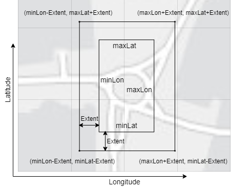
The function computes the geographic bounding box coordinates using latitude and
longitude GPS data and the specified extent value. The center of
the bounding box is the geographical reference point specified by the values of the
georeference property. The minimum and maximum latitude and
longitude values in the structure represent a rectangular bounding box. This diagram
displays the relationship between these coordinates.