Main Content

seaSurfaceHeight

R2026b

Generate sea surface height using wave spectrum models

Since R2026b

    Description

    Add-On Required: This feature requires the Underwater Acoustic Channels add-on.

    seaHeight = seaSurfaceHeight(boundary,resolution) generates sea surface heights between the specified boundaries at the given resolution.

    example

    seaHeight = seaSurfaceHeight(___,Name=Value) specifies options using one or more name-value arguments.

    Examples

    collapse all

    Generate sea surface heights for the range 10 m to 500 m at a resolution of 0.1 m. Specify a wind speed of 12 m/s.

    boundary = [10 500];
    resolution = 0.1;
    seaHeights = seaSurfaceHeight(boundary,resolution,WindSpeed=12);

    Visualize the generated heights in a plot.

    plot(seaHeights(:,1),seaHeights(:,2))
    xlabel("Distance (m)")
    ylabel("Height (m)")
    title("Sea Surface Height")
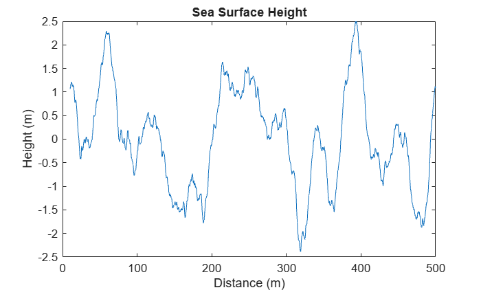
    Figure contains an axes object. The axes object with title Sea Surface Height, xlabel Distance (m), ylabel Height (m) contains an object of type line.

    Input Arguments

    collapse all

    Sea range boundaries in meters, specified as a 1-by-2 row vector of strictly increasing values. Sea surface heights are generated from the first boundary value to the second boundary value at increments specified by resolution.

    Data Types: double | single

    Sea range resolution in meters, specified as a positive scalar. The range specified by boundary must be divisible by resolution.

    Data Types: double | single

    Name-Value Arguments

    collapse all

    Specify optional pairs of arguments as Name1=Value1,...,NameN=ValueN, where Name is the argument name and Value is the corresponding value. Name-value arguments must appear after other arguments, but the order of the pairs does not matter.

    Example: seaSurfaceHeight(boundary,resolution,SpectrumModel="jonswap")

    Sea spectrum model, specified as "pm" to use the Pierson-Moskowitz spectrum [1], "bretschneider" to use the Bretschneider (ISSC) spectrum [2], or "jonswap" to use the Joint North Sea Wave Project (JONSWAP) spectrum [3].

    Data Types: char | string

    Wind speed in meters per second, specified as a positive scalar.

    Specify WindSpeed as the wind speed at an elevation of 10 meters above water. Specify WindSpeed only when you use the Pierson-Moskowitz and JONSWAP spectra.

    Data Types: double | single

    Significant wave height in meters, specified as a nonnegative scalar. The significant wave height is defined as the average of the top one-third of wave heights observed. Specify SignificantWaveHeight only when you use the Bretschneider spectrum.

    Data Types: double | single

    Peak wave period in seconds, specified as a positive scalar representing the inverse of the peak frequency in the wave-height spectrum. Specify PeakWavePeriod only when you use the Bretschneider spectrum.

    Data Types: double | single

    Wind fetch in meters, specified as a positive scalar. Fetch is defined as the length over water in which wind blows unobstructed in a fixed direction. Specify Fetch only when you use the JONSWAP spectrum.

    Data Types: double | single

    Peak wave enhancement factor, specified as a positive scalar. The peak enhancement factor is a dimensionless parameter that sharpens the spectral peak relative to the Pierson-Moskowitz spectrum. Specify PeakEnhancementFactor only when you use the JONSWAP spectrum.

    Data Types: double | single

    Output Arguments

    collapse all

    Sea heights, returned as a two-column matrix. The first column is the range in meters as defined by boundary and resolution. The second column is the generated sea height at the corresponding range.

    References

    [1] Pierson, Willard J., and Lionel Moskowitz. “A Proposed Spectral Form for Fully Developed Wind Seas Based on the Similarity Theory of S. A. Kitaigorodskii.” Journal of Geophysical Research 69, no. 24 (1964): 5181–90. https://doi.org/10.1029/JZ069i024p05181.

    [2] Bretschneider, CL. "Wave variability and wave spectra for wind-generated gravity waves." US Army Corps of Engineers, Beach Erosion Board. Tech. Memo. 113 (1959).

    [3] Hasselmann, Klaus, Tim P. Barnett, E. Bouws, H. Carlson, David E. Cartwright, K. Enke, J. A. Ewing et al. "Measurements of wind-wave growth and swell decay during the Joint North Sea Wave Project (JONSWAP)." Ergaenzungsheft zur Deutschen Hydrographischen Zeitschrift, Reihe A (1973).

    Version History

    Introduced in R2026b