Acquire Depth Image from Basler ToF blaze-101 Camera and View as Point Cloud
This example shows how to acquire a range map from a GenICam™ compliant Basler ToF blaze-101 camera and visualize it as a point cloud.
For an example of acquiring a point cloud directly from a camera, see Acquire and View Point Cloud from Basler ToF blaze-101 Camera.
Requirements
This example requires the following add-ons:
Image Acquisition Toolbox™
Image Acquisition Toolbox Support Package for GenICam™ Interface
Connect to Camera
Create a videoinput object using the gentl adaptor. The example selects the first device and Coord3D_C16 pixel format to acquire 2D depth images from Basler ToF blaze-101 camera. You can view all the available device using imaqhwinfo.
vid = videoinput("gentl", 1, "Coord3D_C16");
Configure the camera for manual triggering. You will use the snapshot in a loop technique described in the example Acquire Single Image in Loop Using getsnapshot.
triggerconfig(vid, "manual");Configure Camera
Retrieve the videosource object.
src = getselectedsource(vid);
Configure the camera to stream using the Range component to access range maps and disable all other components.
src.ComponentSelector = "Intensity";
src.ComponentEnable = "False";
src.ComponentSelector = "Confidence";
src.ComponentEnable = "False";
src.ComponentSelector = "Range";
src.ComponentEnable = "True";
Configure the minimum depth of the camera.
src.DepthMin = 0;
Set Scan3dCoordinateSelector property to "CoordinateC", which represents Z axis, and retrieve the depth-to-distance conversion factor by reading the value of Scan3dCoordinateScale property. This is used while converting the range map into a point cloud.
src.Scan3dCoordinateSelector = "CoordinateC";
% Depth-to-distance(mm) conversion factor
gray2mm = src.Scan3dCoordinateScale;
Start Acquisition
Preallocate the height and width of the range map.
videoResolution = vid.VideoResolution;
rangeMap = zeros(videoResolution(2), videoResolution(1), 0);
Start the camera streaming.
start(vid)
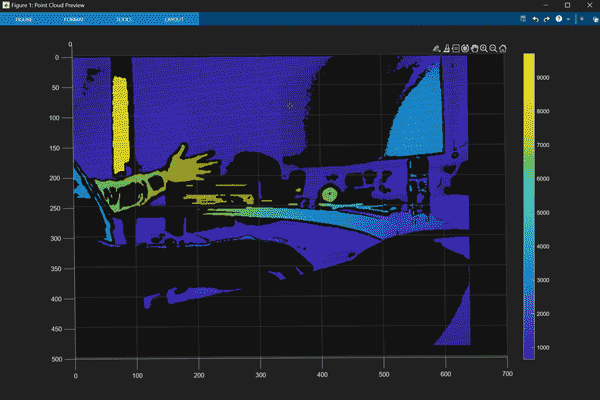
Create a Scatter Plot to View the Range Map as a Point Cloud
To create a point cloud, you need the X, Y, and Z coordinates. You get the X and Y coordinates using the find function. The Z coordinate is calculated using the following formula:
Capture a single image.
img = getsnapshot(vid);
rangeMap(:, :, end+1) = img;
Get X and Y coordinates from the image.
[y, x] = find(img);
Store the depth (Z coordinate) values from the pixels.
z = zeros(numel(x), 1);
for i = 1:numel(x)
    % Acquire the pixel data from the image
    pixelValue = img(y(i), x(i));
    % Calculate z-coordinate value using the above formula
    z(i) = pixelValue * gray2mm;
end
Create a scatter3 object.
fig = figure(Name="Point Cloud Preview");
hscatter = scatter3(x, y, z, 1, z, "filled");
% Add colormap and colorbar
colormap(gca, "parula");
colorbar;
% Turn the axis rotation on.
rotate3d on;
Stream Point Cloud and Acquire Range Map
Stream and save range data until the scatter3 plot is closed.
while ishandle(hscatter)
    img = getsnapshot(vid);
    rangeMap(:, :, end+1) = img;
    [y, x] = find(img);
    z = zeros(numel(x), 1);
    for i = 1:numel(x)
        % Acquire the pixel data from the image
        pixelValue = img(y(i), x(i));
        % Calculate z-coordinate value using the above formula
        z(i) = pixelValue * gray2mm;
    end
    if ishandle(hscatter)
        % Update scatter3 plot
        set(hscatter, XData=x, YData=y, ZData=z, CData=z);
    end
end
clear hscatter;
clear fig;
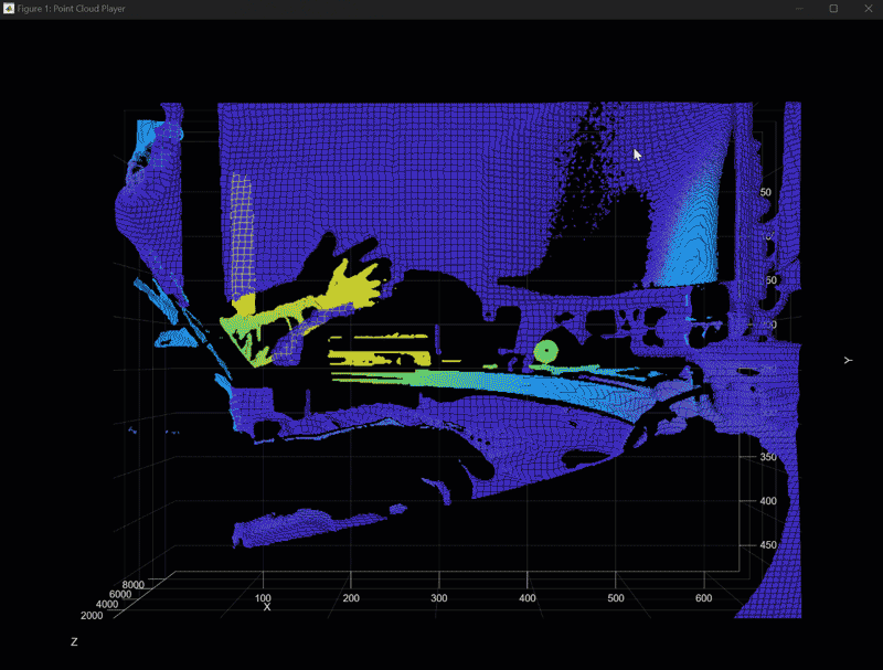
View Point Cloud While Acquiring Range Map
You can also convert the data into a pointCloud object and use pcplayer to visualize point cloud data.
Create a pcplayer object.
player = pcplayer([min(x) max(x)], [min(y) max(y)], [min(z) max(z)]);
Stream point cloud data until pcplayer is closed.
ptCloud = [];
while isOpen(player)
    img = getsnapshot(vid);
    rangeMap(:, :, end+1) = img;
    [y, x] = find(img);
    z = zeros(numel(x), 1);
    for i = 1:numel(x)
        % Acquire the pixel data from the image
        pixelValue = img(y(i), x(i));
        % Calculate z-coordinate value using the above formula
        z(i) = pixelValue * gray2mm;
    end
    ptCloud = [ptCloud pointCloud([x,y,z], "Intensity", z)];
    view(player, ptCloud(end))
end
Clean Up
stop(vid);
delete(vid);
See Also
Functions
pcplayer(Computer Vision Toolbox) |pointCloud(Computer Vision Toolbox)