Main Content

location

Coordinates at distance and angle from site

Description

sitelocation = location(site) returns the site location of the antenna.

[lat,lon] = location(site) returns the latitude and longitude of the antenna site.

This syntax only supports antenna sites with a CoordinateSystem property value of 'geographic'.

example

[___] = location(site,distance,azimuth) returns the new location achieved by moving the antenna site by the distance specified in the direction of the azimuth angle. The location is calculated by moving along a great circle path using a spherical Earth model.

This syntax only supports antenna sites with a CoordinateSystem property value of 'geographic'.

Examples

collapse all

Create a site 1 km north of a given site.

Create the first transmitter site.

tx = txsite(Name="MathWorks",Latitude=42.3001,Longitude=-71.3504);

Calculate the location 1 km north of the first site.

[lat,lon] = location(tx,1000,90)
lat = 42.3091
lon = -71.3504

Create a second transmitter site at the location specified by lat and lon.

tx2 = txsite(Name="Second transmitter",Latitude=lat,Longitude=lon);

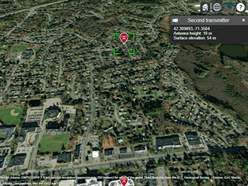
Show the two transmitter sites.

show([tx tx2])

Two transmitter sites displayed over a satellite basemap. An information box shows the coordinates, antenna height, and surface elevation for the second transmitter.

Input Arguments

collapse all

Antenna site, specified as an array of txsite and rxsite objects. You can also specify a scalar object.

Note

If distance or azimuth is a vector, then site must be a scalar.

Distance to move antenna site, specified as a scalar or vector in meters.

Azimuth angle, specified as a scalar or vector in degrees. Azimuth angle is measured counterclockwise from due east.

Output Arguments

collapse all

Location of antenna site, returned as an M-by-2 matrix with each element unit in degrees. M is the number of sites in sites. The location value includes the latitude and longitude of the antenna site.

If the antenna site has the CoordinateSystem property set to 'geographic', L is a 1-by-2 vector in degrees latitude and longitude. The output longitude wrapped so that values are in the range [-180 180]. If SITE has CoordinateSystem set to 'cartesian', L is a 1-by-3 vector.

Latitude of one or more antenna sites, returned as an M-by-1 vector with each element unit in degrees. M is the number of sites in site.

Longitude of one or more antenna sites, returned as an M-by-1 matrix with each element unit in degrees. M is the number of sites in site. The output is wrapped so that the values are in the range [-180 180].

Version History

Introduced in R2019b

See Also

| | |